搜索结果: 1-15 共查到“水文气象学 Data”相关记录15条 . 查询时间(0.281 秒)

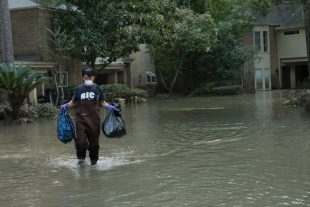
Decade of data shows FEMA flood maps missed 3-in-4 claims(图)
Decade data FEMA flood maps missed 3-in-4 claims
2017/9/20
An analysis of flood claims in several southeast Houston suburbs from 1999 to 2009 found that the Federal Emergency Management Agency’s 100-year flood plain maps — the tool that U.S. officials use to ...
Assessing hydrometeorological impacts with terrestrial and aerial Lidar data in Monterrey, México
Hidrometeorological impacts Lidar Environmental policy Risk Management
2014/4/22
Light Detection Ranging (Lidar) is an efficient tool to gather points reflected from a terrain and store them in a xyz coordinate system, allowing the generation of 3D data sets to manage geoinformati...
Evapotranspiration modelling at large scale using near-real time MSG SEVIRI derived data
Evapotranspiration modelling using near-real MSG SEVIRI
2011/3/15
We present an evapotranspiration (ET) model developed in the framework of the EUMETSAT "Satellite Application Facility" (SAF) on Land Surface Analysis (LSA). The model is a simplified Soil-Vegetation-...
Characteristics of 2-D convective structures in Catalonia (NE Spain):an analysis using radar data and GIS
2-D convective structures Catalonia analysis radar data GIS
2010/2/1
Flood simulation studies use spatial-temporal rainfall data input into distributed hydrological models. A correct description of rainfall in space and in time contributes to improvements on hydrologic...
WATER VAPOR BALANCE OF THE ATMOSPHERE FROM FIVE YEARS OF HEMISPHERIC DATA
WATER VAPOR BALANCE ATMOSPHERE HEMISPHERIC DATA
2009/10/30
The atmospheric balance of water vapor for the northern hemisphere is
investigated through entirely automatic data processing and objective
analysis procedures, in order to assess the potentialities...
POLE-TO-POLE WATER BALANCE FOR THE IGY FROM AEROLOGICAL DATA
POLE-TO-POLE WATER BALANCE IGY AEROLOGICAL DATA
2009/10/29
The present study gives a discussion of the water balance on a planetary
scale during the IGY covering the mean and the seasonal conditions for
the calendar year 1958. The study includes analyses of...
Improved estimation of flood parameters by combining space based SAR data with very high resolution digital elevation data
synthetic aperture radar devastating catastrophes flood parameters
2009/7/22
Severe flood events turned out to be the most devastating catastrophes for Europe's population, economy and environment during the past decades. The total loss caused by the August 2002 flood is estim...
A grid-based distributed flood forecasting model for use with weather radar data:Part 2. Case studies
flood forecasting model rainfall-runoff model weather radar data
2009/6/5
A simple distributed rainfall-runoff model, configured on a square grid to make best use of weather radar data, was developed in Part 1 (Bell and Moore, 1998). The simple form of the basic model, ref...
Significance of spatial variability in precipitation for process-oriented modelling:results from two nested catchments using radar and ground station data
rainfall spatial resolution temporal resolution
2009/5/18
The importance of considering the spatial distribution of rainfall for process-oriented hydrological modelling is well-known. However, the application of rainfall radar data to provide such detailed s...
Regional climate model data used within the SWURVE project – 2:addressing uncertainty in regional climate model data for five European case study areas
uncertainty European regional climate mode temperature
2009/5/8
To aid assessments of the impact of climate change on water related activities in the case study regions (CSRs) of the EC-funded project SWURVE, estimates of uncertainty in climate model data need to ...
Regional climate model data used within the SWURVE project – 1:projected changes in seasonal patterns and estimation of PET
PET rainfall HadRM3H temperature
2009/5/8
Climate data for studies within the SWURVE (Sustainable Water: Uncertainty, Risk and Vulnerability in Europe) project, assessing the risk posed by future climatic change to various hydrological and hy...
Comparison of data-driven methods for downscaling ensemble weather forecasts
statistical downscaling model evolutionary polynomial regression medium range forecast
2009/4/29
This study investigates dynamically different data-driven methods, specifically a statistical downscaling model (SDSM), a time lagged feedforward neural network (TLFN), and an evolutionary polynomial ...
A 59-year (1948-2006) global meteorological forcing data set for land surface models. Part II: Global snowfall estimation
meteorological forcing data Global snowfall
2009/4/13
Global terrestrial snowfall was estimated for 59 years from 1948 to 2006 by applying gauge undercatch correction for snowfall and rainfall based on daily meteorological data and gauge type. Following ...
A 59-year (1948-2006) global near-surface meteorological data set for land surface models. Part I: Development of daily forcing and assessment of precipitation intensity
meteorological data land surface models precipitation intensity
2009/4/13
This paper describes the development and assessment of global 0.5° near-surface atmospheric data from 1948 to 2006 at daily (for precipitation, snowfall, and specific humidity) to 3-hourly (for temper...
Snow Surveys and Hydrometeorology Data Collection in 2009 Winter Field Season at Smith Creek Basin
Snow Surveys Hydrometeorology Data Collection 2009 Winter Field Season Smith Creek Basin
2014/4/2
This report describes the data collection being conducted in 2009 winter field season at Smith Creek Basin. The data collection consists of two components: snow surveys and hydrometeorology. The follo...

